Sarnano /de
Deutsch Sprach-Codes: siehe Property:Has Language SPRACHE
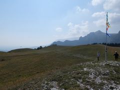
Piani di Montioli, Montioli
Beschreibungen : http://www.aeroclubdeisibillini.it/it/menu/i-nostri-voli.html
Wetter und Webcam: http://www.aeroclubdeisibillini.it/en/meteo.html
Contents
- 1 Fluggebiet
- 2 Umgebung
- 3 Veranstaltungen
- 4 Erfahrungs- und Reiseberichte
- 5 Revision
Fluggebiet
Startplätze
BILD
Startplatz Montioli

Koordinaten: 43° 2' 22", 13° 14' 29"
Startart: Hangstart
Startrichtung: NE,ENE,E,ESE,SE
Höhe: 1170m
Höhendifferenz: 717m
-Coming from Macerata on the state route SS 78: after the intersection with route 502 at Pian di Pieca continue in direction Sarnano for 500 meters, turn right at the signpost for the convent of ‘San Liberato’ and follow the road uphill for 3 kilometers beyond the convent. -Coming from Sarnano on the state route SS 78: after the ‘La Marchigiana’ restaurant, turn left at the intersection just before the ‘Laminox’ industrial building and follow the road uphill for 4 kilometers. After the road exits the forest onto a high plain, park the car on the left (south) side of the road. Do NOT park on the grass: the rangers are very severe with parking fines. East oriented: good wind NE – SE (easy takeoff for hang glider and paraglider)
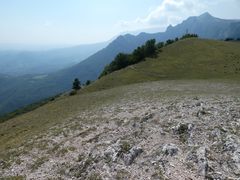
Montioli Startplatz
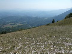
Montioli Startplatz

Montioli Aufbauplatz
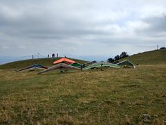
Montioli Aufbauplatz
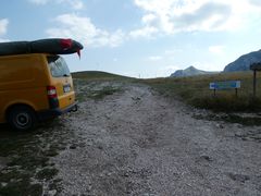
Montioli Parkplatz
Tragstrecke zum Startplatz


Startplatz Montioli Croce
Koordinaten: 43° 2' 27", 13° 14' 0"
Startart: Hangstart
Startrichtung: NE,ENE,E
Höhe: 1252m
Höhendifferenz: 717m


Startplatz Montioli Lu Re
Koordinaten: 43° 2' 34", 13° 14' 2"
Startart: Hangstart
Startrichtung: N,NNE,NE
Höhe: 1241m
Höhendifferenz: 717m


Startplatz Pizzo di Meta
Koordinaten: 43° 1' 4", 13° 14' 20"
Startart: Hangstart
Startrichtung: S,SSE,SE
Höhe: 1576m
Höhendifferenz: 1017m
Coming from Sarnano towards Sassotetto, turn right (east) on the unpaved road in the upper ski parking area and climb along the side of the hill for 1 kilometer until the road ends. East oriented: good wind S – SE (difficult takeoff for hang glider and paraglider) Landing Zone Gabella Nuova: (see above) Elevation difference: 1017 m. Distance: 4.3 kilometers Glide ratio: 4.3 Landing Zone Camping '4 Stagioni' 526 meters msl (43º01.281'N 013º16.920'E) Coming from Sarnano towards Sassotetto near the campground 'Le Quattro Stagioni', located north of the swimming pool easily visible from the air. Large grassy level fenced field without windsock (intermediate for hang glider and easy for paraglider) Elevation difference: 1015 m. Distance: 3,6 kilometers Glide ratio: 3,5
Startplatz Sassotetto
Koordinaten: 43° 0' 18", 13° 13' 54"
Startart: Hangstart
Startrichtung: NE,ENE,E
Höhe: 1624m
Höhendifferenz: 1015m
Coming from Sarnano towards Sassotetto, park in the upper ski parking area and climb up the ski slope (summer) or take the ski lift (winter). East oriented: good wind NE – E (difficult takeoff for paraglider)
Startplatz La Rocca
Koordinaten: 43° 3' 57", 13° 15' 13"
Startart: Hangstart
Startrichtung: N,NE,ENE,E
Höhe: 841m
Höhendifferenz: 361m
Coming from the convent of San Liberato towards Pian di Pieca, about 1 kilometer below the convent, turn left (north) at the hairpin curve with the signpost for ‘La Rocca’. Keep to the left and climb along the side of the hill for 1 kilometer until the road turns west at the crest and park in the turnout. A brief track (150 m) leads up to the launch area. Do NOT drive to the launch area: the rangers are very severe with parking fines. East oriented: good wind N – E (easy takeoff for hang glider and paraglider) Landing Zone Pian di Pieca (see above) Elevation difference: 361 m. Distance: 1.2 kilometers Glide ratio: 3.3
Startplatz Prati di Ragnolo
Koordinaten: 43° 1' 39", 13° 13' 0"
Startart: Hangstart
Startrichtung: NW,WNW,W,WSW,SW
Höhe: 1395m
Höhendifferenz: m
Coming from the convent of San Liberato towards takeoff Montioli, about 1 kilometer beyond the takeoff, turn left (south) at the intersection towards Bolognola and follow for 800 meters. Park the car near the chained fire access road on the left (east) side of the road. Do NOT park on the grass. West oriented: good wind NW – SW (easy takeoff for hang glider and paraglider) Landing Zone Prati di Ragnolo: Landing is possible anywhere in the high plain area. Very large, grassy, treeless, slightly-inclined, unfenced field without windsock (easy for hang glider and paraglider)
Startplatz Ovest
Koordinaten: 43° 0' 55", 13° 12' 53"
Startart: Hangstart
Startrichtung: NW,WNW,W
Höhe: 1488m
Höhendifferenz: m
Coming from the convent of San Liberato towards takeoff Montioli, about 1 kilometer beyond the takeoff, turn left (south) at the intersection towards Bolognola and follow for 2 kilometers. Park the car near the turnout for the cross country ski chalet. Do NOT park on the grass. Northwest oriented: good wind NW – W (easy takeoff for hang glider and paraglider) Landing Zone Prati di Ragnolo: (see above)
Startplatz Macereto
Koordinaten: 42° 59' 14", 13° 8' 27"
Startart: Hangstart
Startrichtung: W,WSW,SW
Höhe: 1500m
Höhendifferenz: 343m
Coming from the convent of San Liberato towards takeoff Montioli, about 1 kilometer beyond the takeoff, turn right (north) at the intersection towards Fiastra and follow for 4 kilometers. At Fiastra turn left (south) for Monte Coglia and follow the road past the radio antennae 2 kilometers. Park the car on the side of the road near the Piani di Pao. Do NOT park on the grass. West oriented: good wind W – SW (easy takeoff for hang glider and paraglider) Landing Zone Piane di Macereto: 1157 meters msl (42º59.239'N 013º08.442'E) Large, grassy, slightly-inclined, unfenced field without windsock (intermediate for hang glider and easy for paraglider) Elevation difference: 343 m. Distance:1,2 kilometers Glide ratio: 3,4
Startplatz Fiastra
Koordinaten: 43° 1' 16", 13° 8' 58"
Startart: Hangstart
Startrichtung: N,NNE,NE
Höhe: 1296m
Höhendifferenz: 638m
Coming from the convent of San Liberato towards takeoff Montioli, about 1 kilometer beyond the takeoff, turn right (north) at the intersection towards Fiastra and follow for 4 kilometers. At Fiastra turn left (south) for Monte Coglia and follow the road 2 kilometers. Park the car on the side of the road near the radio antennae. Do NOT park on the grass. North oriented: good wind N – NE (easy takeoff for hang glider and paraglider) Landing Zone Fiastra: 658 meters msl (43º02.572'N 013º10.097'E) To the right (east) of the lake near the road, grassy, level, unfenced field without windsock (intermediate for hang glider and paraglider) Elevation difference: 638 m. Distance:2,870 kilometers Glide ratio: 4,5
Landeplätze
Landeplatz Gabella Nuova
Koordinaten: 43° 3' 3", 13° 16' 9"
Höhe: 559m
-About halfway from Pian di Pieca to Sarnano on the state route SS 78, at the south end of Gabella Nuova , turn right (west) on the unpaved road and follow for 500 meters. Large grassy level unfenced field with windsock (intermediate for hang glider and easy for paraglider) Elevation difference: 611 m. Distance: 2.5 kilometers Glide ratio: 4.2


Landeplatz Pian di Pieca

Koordinaten: 43° 4' 39", 13° 16' 13"
Höhe: 480m
Coming from Sarnano on the state route SS 78: turn left at the intersection with route 502 at Pian di Pieca in direction Caldarola and follow for 500 meters, turn left on route 91 in direction Fiastra and follow for another 500 meters. Very large grassy level unfenced field with windsock (easy for hang glider and paraglider) Elevation difference: 690 m. Distance: 4.8 kilometers Glide ratio: 6.9


Landeplatz Camping 4 Stagioni
Koordinaten: 43° 1' 17", 13° 16' 55"
Höhe: 526m
Coming from Sarnano towards Sassotetto near the campground 'Le Quattro Stagioni', located north of the swimming pool easily visible from the air. Large grassy level fenced field without windsock (intermediate for hang glider and easy for paraglider) Elevation difference: 1015 m. Distance: 3,6 kilometers Glide ratio: 3,5
Landeplatz Piane di Macereto
Koordinaten: 42° 59' 14", 13° 8' 27"
Höhe: 1157m
Large, grassy, slightly-inclined, unfenced field without windsock (intermediate for hang glider and easy for paraglider)
Landeplatz Fiastra
Koordinaten: 43° 2' 34", 13° 10' 6"
Höhe: 658m
To the right (east) of the lake near the road, grassy, level, unfenced field without windsock (intermediate for hang glider and paraglider)
Erreichbarkeit und Transport
Anfahrt
ANFAHRT
Auffahrt
Zugänglich über: Straße
BESCHREIBUNG AUFFAHRT
Flug

Streckenflug
BESCHREIBUNG STRECKENFLUGMÖGLICHKEITEN
Bestimmungen und Gebühren
BESTIMMUNGEN UND GEBÜHREN
Besonderheiten
RECHTLICHES; SCHWIERIGKEITEN; WETTERBESONDERHEITEN; GEFAHREN
Weitere Informationen
Wetter
http://www.aeroclubdeisibillini.it/en/meteo.html
Jahresübersicht
| Frühjahr | Sommer | Herbst | Winter |
|---|---|---|---|
| Unbekannt | Unbekannt | Unbekannt | Unbekannt |
| BESCHREIBUNG BEDINGUNGEN IM FRÜHJAHR | BESCHREIBUNG BEDINGUNGEN IM SOMMER | BESCHREIBUNG BEDINGUNGEN IM HERBST | BESCHREIBUNG BEDINGUNGEN IM WINTER |
Bezeichner für Bedingungen: siehe Property:Has Spring cond
EVENTUELL LINK ZU WETTERSEITE
Webcam
http://www.aeroclubdeisibillini.it/server/swpi_camera1.php
Videos
Weitere Beschreibungen
http://www.aeroclubdeisibillini.it/it/menu/i-nostri-voli.html
Flugschulen und Clubs
Treffpunkt
Alternative Gebiete
Automatisch erstelle Liste von Gebieten im Umkreis von 50km:
Castelluccio /de, Gualdo Tadino /de, Monte Cucco /de, Monte Gemmo /de, Monte Subasio /de, Sarnano /de
EVENTUELL WEITERE TIPPS ZU ALTERNATIVEN FLUGGEBIETEN IN DER NÄHE
Umgebung
Kontinent: Europe, Land: Italy, Region: BEZEICHNER in Region, Provinz: BEZEICHNER in Province, Gemeinde: BEZEICHNER in Municipality
Ortschaften
Sarnano
Unterkunft
Camping le Marche 
Gastronomie
TIPPS GASTRONOMIE
Sehenswertes und Aktivitäten
SEHENSWERTES IN DER UMGEBUNG; ALTERNATIVE IDEEN FÜR SCHLECHTES WETTER UND FÜR NICHTFLIEGER
Veranstaltungen
01.01.2000
Erfahrungs- und Reiseberichte
LINKS ZU REISEBERICHTEN MIT KURZBESCHREIBUNG(REISEBERICHTE IN EIGENEM NAMESPACE REPORT:)
Revision
Status: Benötigt Überarbeitung? BEZEICHNER Needs Revision state"BEZEICHNER Needs Revision state" is not in the list (None, Low, Mid, High) of allowed values for the "Needs Revision state" property.
Bezeichner: siehe Property:Needs Revision state
Status: Benötigt Medien? BEZEICHNER Needs Media state"BEZEICHNER Needs Media state" is not in the list (Picture, Video, Webcam, Weather) of allowed values for the "Needs Media state" property.
Bezeichner: siehe Property:Needs Media state
Bearbeiter: Vilenya
Longitude: 13.269027777778 +, 43° 4' 39", 13° 16' 13"Latitude: 43.077472222222
Longitude: 13.270388888889 +, 43° 1' 17", 13° 16' 55"Latitude: 43.021361111111
Longitude: 13.282 +, 42° 59' 14", 13° 8' 26"Latitude: 42.987305555556
Longitude: 13.140694444444 + and 43° 2' 34", 13° 10' 6"Latitude: 43.042861111111
Longitude: 13.168277777778 +
Longitude: 13.2415 +, 43° 2' 26", 13° 14' 0"Latitude: 43.040694444444
Longitude: 13.233222222222 +, 43° 2' 34", 13° 14' 2"Latitude: 43.042861111111
Longitude: 13.233777777778 +, 43° 1' 4", 13° 14' 20"Latitude: 43.017777777778
Longitude: 13.238861111111 +, 43° 0' 18", 13° 13' 54"Latitude: 43.005111111111
Longitude: 13.231638888889 +, 43° 3' 57", 13° 15' 13"Latitude: 43.065944444444
Longitude: 13.253722222222 +, 43° 1' 39", 13° 13' 0"Latitude: 43.027527777778
Longitude: 13.216722222222 +, 43° 0' 55", 13° 12' 53"Latitude: 43.015361111111
Longitude: 13.214805555556 +, 42° 59' 14", 13° 8' 26"Latitude: 42.987305555556
Longitude: 13.140694444444 + and 43° 1' 16", 13° 8' 58"Latitude: 43.021111111111
Longitude: 13.149333333333 +