Galicica /de
Deutsch SPRACHE

Galicica
HG und GS?
Fluggebiet direkt am Ohridsee, traumhafte Aussicht, Soaringkante
Mt. Galicica
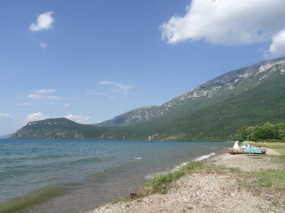
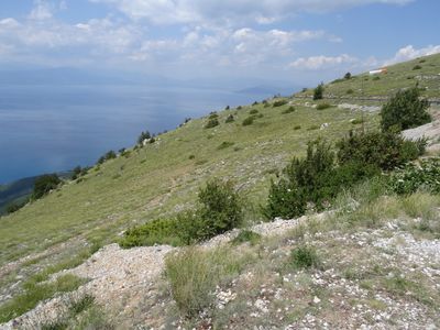
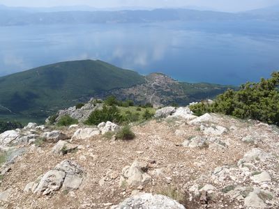
The take off site is situated on SE part of Ohrid Lake, 30 minutes drive from the Ohrid Town, and is accessed by a tarmac road. At a height of 1550 ASL, the grassy take off slope, looking over the Ohrid Lake. Take off faces west and so the flying day starts afternoon around 1pm. Main landings is grassy fields near to Village of Ljubanista on 700 m ASL. Flying season is from April to October.
Contents
- 1 Fluggebiet
- 2 Umgebung
- 3 Veranstaltungen
- 4 Erfahrungs- und Reiseberichte
- 5 Revision
Fluggebiet
Startplatz

Startart: Hang
Startrichtung: W,WNW,WSW
Höhe: 1580m
Höhendifferenz: 886m
per Auto, zu Fuß
mittelsteiler Naturstart viel Aufbauplatz
The main launch towards the southern end of the ridge is reached by a tarmac road. There are often shuttles going up with the tandem companies and taxis are cheap. Hitch-hiking can work but there aren’t that many cars going up. It’s best for pilots to hook up with the local clubs.
There is another launch closer to Ohrid city but this involves going up a dirt track that requires a 4-x-4, so you will need to hitch a ride with one of the tandem companies that use it.
Landeplatz GS Strand
Koordinaten: 40° 55' 26", 20° 46' 0"
Höhe: 694m
per Auto, zu Fuß
kleines Feld fast direkt am Strand
Landemöglichkeit HG?
Koordinaten: 40° 55' 19", 20° 45' 54"
Höhe: 694m
per Auto, zu Fuß
große Nord-Süd Wiese südlich vom See und GS-Landeplatz. Wohl inoffiziell, vorher schauen und fragen.
Erreichbarkeit und Transport
Anfahrt
Auffahrt
Zugänglich über: Straße
Flug
Mit genügend Wind schönes Soaring möglich
Running along the east side of the lake is a large mountain ridge that faces west giving good flying conditions especially in the afternoons and evenings.
FLYING CONDITIONS It’s a west-facing slope with a steep rocky face which can create strong conditions but gives very smooth thermals in the afternoons. It usually starts around one o’clock in the afternoon and is flyable until sunset. The conditions are consistent across the year. Most people stick to flying along the lake shore which is a 30km ridge offering nice-out-and-returns.
MUST BE FLOWN The out-and-return to Ohrid is very beautiful and you can finish the flight by landing at St. Naum Monastery on the border with Albania, where there are lots of fish restaurants for après-vol.
WATCH OUT FOR Early in the day in can be quite strong on the rocky faces. Landing options between take-off and Ohrid are limited especially for hang gliders. The national park have a daily fee of five euros for flying.
Streckenflug
Bestimmungen und Gebühren
Besonderheiten
Weitere Informationen
Wetter
Jahresübersicht April bis Oktober
| Frühjahr | Sommer | Herbst | Winter |
|---|---|---|---|
| Unbekannt | Unbekannt | Unbekannt | Unbekannt |
| BESCHREIBUNG BEDINGUNGEN IM FRÜHJAHR | BESCHREIBUNG BEDINGUNGEN IM SOMMER | BESCHREIBUNG BEDINGUNGEN IM HERBST | BESCHREIBUNG BEDINGUNGEN IM WINTER |
Holfuy: https://holfuy.com/en/data/210 https://holfuy.com/en/data/209 https://holfuy.com/en/data/208
Webcam
Videos
- https://www.youtube.com/watch?v=58B2BGSXnLo
- https://www.youtube.com/watch?v=7sHxDeyt3y0
- https://www.youtube.com/watch?v=9Vpbhz92wQc&feature=emb_logo
- https://www.youtube.com/watch?v=r-ujPXYyawU
- https://vimeo.com/13293877
Weitere Beschreibungen
- https://xcmag.com/travel-guide/europe/guide-to-ohrid-macedonia/
- https://www.dhv.de/db2/details.php?qi=glp_details&popup=1&item=3484
- https://krusevopen.wixsite.com/xscfly/flying_sites
Flugschulen und Clubs
Treffpunkt
Alternative Gebiete
Automatisch erstelle Liste von Gebieten im Umkreis von 50km:
Galicica /de, Korca /de, Krushevo /de
Umgebung
Kontinent: Europe, Land: North Macedonia, Region: BEZEICHNER in Region, Provinz: BEZEICHNER in Province, Gemeinde: BEZEICHNER in Municipality
Ortschaften
Ljubanishta
Unterkunft
Einige Campingplätze
ACCOMMODATION There is plenty of lakeside accommodation in villas and hotels as well as camping options, with Ljubanista Camping being closest to the landing. If you stay in Ohrid City it takes an hour to get to launch.
Gastronomie
- Ribar Restaurant
Sehenswertes und Aktivitäten
TAKE THE FAMILY AND RAINY DAYS Ohrid lake is the oldest and deepest lake in Europe with unusually clean water so a great vacation spot. There are many churches in the area, the town once having as many as 365, and an old fishing port that has been restored and is now a museum. You could always visit the big castle tht lies on a hill in the centre of town, plus of course the vibrant city has plenty of cafes and bars. There are lots of biking and hiking trails on the mountain, and the hike to the top is quite a highlight.
Veranstaltungen
01.01.2000
Erfahrungs- und Reiseberichte
Revision
Status: Benötigt Überarbeitung? BEZEICHNER Needs Revision state"BEZEICHNER Needs Revision state" is not in the list (None, Low, Mid, High) of allowed values for the "Needs Revision state" property.
Status: Benötigt Medien? BEZEICHNER Needs Media state"BEZEICHNER Needs Media state" is not in the list (Picture, Video, Webcam, Weather) of allowed values for the "Needs Media state" property.
Bearbeiter: Vilenya
